Image copyright
Getty Images
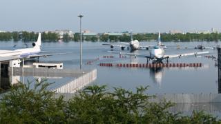
Heavy rain on a high tide flooded Don Mueang Airport in Bangkok in 2011
Millions more people will be at risk of coastal flooding from climate-driven sea-level rise later this century.
That’s the conclusion of new research conducted by Climate Central, a US-based non-profit news organisation.
It finds that 190 million people will be living in areas that are projected to be below high-tide lines come 2100.
Today, the group calculates roughly 110 million are presently occupying these lands, protected by walls, levees, and other coastal defences.
The future at-risk total assumes only moderate global warming and therefore limited ocean encroachment.
Climate Central’s investigations, published in the journal Nature Communications, have sought to correct the biases in the elevation datasets previously used to work out how far inland coastlines will be inundated.
The projection assumes greenhouse gas emissions remain high
The most famous of these datasets comes from a space shuttle mission.
The Endeavour orbiter used a radar instrument in 2000 to map heights across the globe. This 3D model of the planet has become one of the most used Earth observation datasets in history.
But the Climate Central team, of Scott Kulp and Benjamin Strauss, says it suffers from biases that in places make the land look higher than it really is.
This problem occurs particularly in locations where there is thick vegetation, such as forests; the radar tends to see the tree canopy, not the ground.
Kulp and Strauss used more modern, higher-resolution information from airborne lidar (laser) instruments to train a computer to make corrections to the shuttle’s digital elevation model (DEM).
When this new CoastalDEM is used in tandem with population statistics and the latest forecasts for sea level rise, it becomes apparent that many more people are entering a precarious future.
The improved elevation data finds that even with moderate reductions in greenhouse gas emissions, six Asian countries (China, Bangladesh, India, Vietnam, Indonesia, and Thailand), where 237 million people live today, could face annual coastal flooding threats by 2050. That’s roughly 183 million more than assessments based on prevailing elevation data.
New estimate versus old estimate
- China – 93 million vs 29 million
- Bangladesh – 42 million vs 5 million
- India – 36 million vs 5 million
- Vietnam – 31 million vs 9 million
- Indonesia – 23 million vs 5 million
- Thailand – 12 million vs 1 million
The team has produced an interactive map that illustrates the difference between estimates based solely on the shuttle legacy data and the reworked elevations.
And it’s possible to see on this map how circumstances change depending on how well the world manages to constrain climate warming, which is pushing up ocean levels by heating the seas and melting ice stored in Antarctica and Greenland.
Under a pessimistic future of continued high emissions, CoastalDEM suggests up to 630 million people live today on land that is projected to have annual flood events by 2100.
For 2050, this number is 340 million, up from the estimated 250 million people who already live in this predicament.
In general, the CoastalDEM-derived estimates of the global population at risk from coastal flooding are three times greater than the values produced using just the shuttle information.
“We estimate one billion people now occupy land less than 10m above current high tide lines, including 250 million below 1m,” the team tells Nature Communications.
The projection assumes greenhouse gas emissions remain high
Sea levels have been rising globally by over 3mm per year in recent decades, with an acceleration in this trend now observable.
The Intergovernmental Panel on Climate Change (IPCC) stated last month in a special report on the oceans that global average sea levels could rise by up to 1.1m by 2100, in the worst warming scenario.
Kulp and Strauss stress some limitations in their analysis.
For example, it assumes a static population – future growth and migration are not considered. Nor are improvements in coastal defences.
On a regional basis, the Climate Central analysis will be less surprising where coastal lidar surveys are already used to assess future flood risk. But its value is significant for those places which don’t enjoy such good coverage.
Image copyright
Ball Aerospace
Artwork: Space Shuttle Endeavour made a 3D map of Earth’s surface in 2000
Source link


